Tag Archives: Panorama

Down in Lansdowne

Originally known as, Kaludanda, after Kalun (Black) and Danda (Hill) in the local language, Lansdowne was founded and named after the then Viceroy of India, Lord Henry Lansdowne in 1887.

IMG_1164Today, Lansdowne is a cantonment town in Pauri Garhwal district of  Uttarakhand and houses the command office of the famous Garhwal Rifles of the Indian Army.

At an elevation of 4600 ft, Lansdowne presents a unique choice of a hill station still in its pristine glory. However this may deter those who would want all the amenities of a comfortable holiday.

It was a three day getaway to this place with family and the sights of this place that relaxed my mind.

This is one of the signs you cannot afford to miss if you are driving on your own (or like us you might end up a little lost).

IMG_1265

The first thing that meets the eye are unending blue pine forests and thick oak trees.

IMG_0550

After a refreshing time in the resort we headed out for the touristy places. First there was the War Memorial, at the Parade Ground of the Garhwal Rifles Center. The Regimental Museum (also called the Darwan Singh Sanghralaya), houses artefacts from the beginning of the Regiment. No photos were allowed of course 😦 only this one of the entrance.

IMG_0631-2

We then headed to the two churches that Lansdowne is known for:

St. Mary’s Church was was built by Colonel AHB Hume in 1896 and has been restored now by Garhwal Rifles Regimental Centre.

st marys church hdr pano2-2 Pre-independence photographs and an audio-visual display of the Regiment’s history can be viewed at this place.

chapel inner st marys pano-2

St. John’s Church is a Roman Catholic Church situated on the mall road. St. John’s Church is the only Church of worship in Lansdowne.

IMG_0658 hdr

st johns church hdr pano-2

Experimented with a bit of HDR to get the feel of the church interiors

chapel inner hdr pano 2-2

The guest book there appeared like a divine list in the light of the window … 🙂

IMG_0667 hdr

The only place that offers a bit of the usual refreshment is the Garhwal Mandal Rest house.

Stitched_002-2

For me this place, was a set straight out of a horror flick!

IMG_0817 hdr

Fortunately, the GMVN is constructing new wooden cottages which I plan to visit if I make this trip again.

IMG_0790

Tip n Top (aka Tiffin Top) is a vantage point that promises both views of the sunrise and sunset, but which also has too many people vying for space.

Stitched_004-2

Because of a technical malfunction in my car I could not wait till sunset and had to head to the local market to get a puncture removed from the tyre.

The evening was spent at Bhulla Taal (Little Brother Lake) which is maintained by the Garhwal Rifles.

IMG_1075The serene waters and the colourful paddle boats were invitation enough for me to exercise my legs and spend the time with the ducks.

IMG_1130-2

Bhulla Taal has its fair share of wildlife, and these guinea pigs kept my little son in splits.

IMG_1101-2

But the best part of the holiday for me was spending time in the balcony of the resort letting in the panoramic view around.

IMG_0500

IMG_0448

The tea they made there was unmatched to any I tasted before!

IMG_0487 hdr

Got a few stills of the birds too…

IMG_0366-2

IMG_1254-2

IMG_1261-2

The evening walk too were fantastic photo ops…

IMG_0559-5

…. and there was enough time to fool around with the camera settings to get a bit artsy

IMG_0622 hdr

And these are a few miscellaneous shots that bear a mention… 


IMG_0826-2 IMG_0913-2 IMG_0916-2


IMG_1249-2


Three days and a lung full of fresh air later, it was time to get back to the grind!

Stitched_001

More and more Marigolds

It seems like they have come up overnight… there are marigolds everywhere. I would never have imagined a simple flower like that when grown in abundance can make the place come ablaze!

So let me take you for a short tour around the Kāsiga school gardens.

The pictures above and below are panorama images of the marigolds on the way to the academic block.

And here is the patch of the same lovely flowers outside the dining hall lawns

Try to spot three different varieties in the maze of gold below…

… or just enjoy the ecstasy of the colours and fragrances!

Can’t wait for the next season of flowers!

Kasiga@Dawn

The Kasiga School announced a cross country run for the students and I was dreading the moment because I was to be on duty at 5:30 am on a Sunday morning!

But when I reached the point where the run was to be flagged off I pointed my camera to the sky and captured some breathtaking moments of the the colours of dawn.

5:30 am – Blue skies at the entrance gate of Kasiga School

6:10 am – Sacred Dawn … the temple and the sun

7:10 am – The sky is ablaze

And here’s the proverbial early bird…

Next time, no cribbing about getting up early!

Ethereal Landscapes

Another drive up to Mussoorie over this weekend. And as we sat lazily watching the clouds go by… This was another of those moments where the landscape looked the same (ie. something I have clicked all too often), yet I wondered how could I capture it through a different lens.

What turned out was indeed a sight to behold!

A rainbow for the teachers

Teacher’s day at the Kasiga School was a memorable one for me… not only because the students didn’t allow me to teach in any class I went to, or that they surprised me with a shower of confetti when I switched on the fan in one of the classrooms or the tiny handmade cards that I got from so many. All this was proof that being a teacher is indeed such a noble profession. And while I walked back home the heavens had something else is store for me. I quickly got out my camera and snapped a panorama of a beautiful rainbow in the sky!

Cheers to teaching and teachers everywhere!

Snakes and Ladders – Chopta Trip

Chopta-Tungnath - Grassy slopesThe mountains and valleys of Uttarakhand never fail to spring surprises on the traveler in search of the picturesque. This summer vacations another dream came true for me, it was the first time I saw snow!

The place was called Chopta—a tiny hamlet in Uttarakhand yet unexplored by travelers offering the most splendid view of the imposing Himalayan range including Trishul, Nanda Devi and Chaukhamba. It is located at an elevation of 2680 mts above sea level.

I owe a lot of information included in this post from the book “Roads to Mussoorie” by Ruskin Bond that was my traveling companion.

Chopta is easily accessible as it is located on the road connecting Gopeshwar with Guptkashi. For me, it was the best 8-hour drive by car in a long time!Chopta-Tungnath - road blocksBut if you are the one at the wheel, you need patience and a good navigator. At many places we had to halt for the earth movers to clear off small landslides, while at other places, we had to trust to map as we traversed ways where roads were extinct.


Sunset Chopta-Tungnath

And this is where we camped for two nights in a tiny guest house that still used firewood to cook the meals and solar heating for the single bulb in the room.

Chopta is also the road head to the ancient temple of Tungnath (3886m), one of the Panch Kedar (five abodes of Shiva).

The next morning was an early rise for the trek from Chopta to TungnathChopta-Tungnath - the trekThe trek from Chopta to Tungnath is only three and a half kilometres, but in that distance one ascends about 3000 feet and at times it is a feeling that you are on a perpendicular path. Or what Ruskin Bond calls it, “a ladder to heaven”

Despite its steepness, there are some hardy souls who would still attempt a shortcut, clawing up tufts of alpine grass, and at time retracing your steps to a better path… a true game of snakes and ladders.

Chopta-Tungnath Steep climbCamp sites on the slopes – for the ones who can brave the icy winds at night

Chopta-Tungnath Camp siteAs we walk along let me give you a brief about the temple we are about to see (from the book by Ruskin Bond)

The temple of Tungnath, at a little over 12,000 feet, is the highest shrine on the inner Himalayan range. Ironically Tungnath Mandir the highest amongst Panch Kedar is easiest one to reach.

It lies just below the Chandrashila peak. Some way off the main pilgrim routes, it is less frequented than Kedarnath or Badrinath, although it forms part of the Kedar temple establishment. Tungnath’s lonely eminence gives it a magic of its own. To get there (or beyond), one passes through some of the most delightful temperate forest in the Garwal Himalaya. Pilgrim, or trekker, one comes away a better person, forest-refreshed, and more aware of what the world was really like before mankind began to strip it bare.

Chopta-Tungnath - Guardian Temple

This is a tiny guardian-temple dedicated to the god ganesha that spurs the tired pilgrim on. But in the cold fresh air and verdant greenery all around you feel intoxicated and least fatigued.

Myriads of wildflowers grow on the open slopes—buttercups, forget-me-not, rock-cress… Chopta-Tungnath - Forest flowers

Chopta-Tungnath - Buttercups

You see all this as you cross a dense rhododendron forest, where in the right season, one can spot at least three species of this flower: the red-flowering tree rhododendron (on the lower slopes), the almatta with light red flowers and the third chimul or white variety at the highest points.

Chopta-Tungnath - rhododendron forests
This rock, reminded me of a UFO from some distant planet landing in the Himalayas… but lets get back to the main story for now

Chopta-Tungnath - UFO

As you approach Tungnath the tree line ends and there is nothing between earth and sky except grass, rock and tiny flowers amidst melting snow.

What was most surprising was that at a height of 13500 feet there were crows to welcome us! And waited for us to throw them scraps of food. I think after cockroaches, crows are the world’s greatest survivors. Another survivor up here is the pika, a sort of mouse-hare, with tiny ears, no tail, grey brown fur and chubby feet.

Chopta-Tungnath Runda

They emerge from their holes under the rocks to forage for grasses on which to feed. The Garwalis call this little creature the runda.

Finally, we made it!

Chopta-Tungnath - Made it

… and I was in the snow!

Chopta-Tungnath - Snow

As I looked around, I couldn’t help but wonder at such a panoramic view of the Himalayas!

Chopta-Tungnath - Snow capped

Chopta-Tungnath - Chandrashila viewThis panorama show the meandering path to Chandrashila from the point where we camped for the morning.

When we did arrive at Tungnath the sky was clear lending a very pleasant and sunny backdrop. To some, the name ‘tung’ indicates ‘lofty’ from the position of the temple on the highest peak outside the main chain of the Himalaya. The temple though not very large, is certainly impressive, mainly because of its setting and the solid slabs of grey granite from which it is built..


Chopta-Tungnath TempleThere are a few guest houses even at this height in case you are interested 🙂 (keep the cold in mind though)

On the way down, tea shop owners beckon and we did stop for a brief moment, to savor the view again

The morning view from Chopta is invigorating when the crimson rays of sun kisses the snow laden Himalayas. It was time to return home again.

Chopta-Tungnath - Morning view

It was here that I came to realize how close Hinduism is to being a nature religion. Rivers, rocks, trees, plants, animals and birds, all play their part, both in mythology and in everyday worship. This harmony is most evident in remote places like this where gods and mountains co-exist. Tungnath yet unspoilt by a materialistic society, exerts its magic on all who come here with open mind and heart.

Supermoon Saturday

The moon on the night of March 19, 2011 was different because it was 356577 km from the earth, one of the closest approaches in the past 18 years… and it gets the label… Supermoon (or scientifically speaking, a lunar perigree)! Going with all the hype created by the media I had to witness this first hand!

supermoon saturday - Dona Paula

The most convenient location that came to mind was the Dona Paula jetty. Good thing I went out here, because at “moon rise”, the moon actually took on a reddish hue…

Supermoon saturday Red Moon

I could not resist taking this night panorama (click on it for a better view)

supermoon saturday pano

But then as it goes with every spectacular “breaking news” everything went back to normal, there were no high tides in the sea, no other celestial phenomenon and the biggest news discussed next was how India crushed West Indies to enter the World cup semi final!

Dam it! in Selaulim

What would be your reaction if you planned a trip, charted the route, packed the essentials and drove two hours to a breathtaking view, only to find security guards who say, NO CAMERAS ALLOWED… well yes… Dam it! Ironically, it was the Selaulim dam that was the target this time. 🙂

Selaulim dam - Sanguem

Thanks to digital camera technology (and cell phone cameras), I did manage to get a few shots from afar…

What's that spray

I read that the Selaulim dam ranks as one of the ten best dams in India… and not surprising. As we walked along the perimeter we were drawn towards a 10 meter high water spray.

Duckbill spillway - Selaulim dam

It was the famed “duckbill spillway” of the Selaulim dam. Water that is released makes its way to over 50% of Goa’s population that includes Salcete, Marmagoa and Quepem Talukas.

Unable to brave too much of the scorching afternoon sun, we moved on… and took a short detour to another archaeological treasure — a ‘transplanted temple.’

Mahadeva Temple, Kurdi - Selaulim

The 11th century Mahadeva Temple is a little distance away from the Selaulim dam.

Garbhagriha - Mahadeva Temple

Originally located on the banks of the river Selaulim. The construction of the dam across the Selaulim river threatened the submergence of this temple hence it was systematically dismantled and reconstructed at this place with a similar topographical setting!

Work of Art Triptych

The triptych displays the complexity of reassembling a work of art — a couple of female devotees on either side of the door jamb, markings on every single stone of the sanctuary and the lintels and drains on the walls

We had spanned the ancient with the modern and it was time to return home.

Ajara via Anmod

There are some places where a single visit is not enough. You have to return to it again and again and discover it anew. Ajara is one such place for me.

Paradise on earth - Ajara

Located just beyond the Amboli ghat it promises a relaxing drive and a weekend photo op. However, this time there was a roadblock in the plan! Amboli, was sealed off because of a landslide. There had to be another way.

Road to Anmod

Anmod! A ghat that I am not too familiar with loomed ahead. Challenge accepted!

Khandepar Bridge, Ponda

So we went through Ponda, crossed the ridiculously narrow Khandepar bridge (which mind you is still NH 4A!) and gasped at the breathtaking sight before us!

Anmod Ghat clouds

Anmod! (literally translates as ‘the place with innumberable turns’)

Misty roads

The clouds look majestic and welcoming from a distance, but once you drive in them, it’s an altogether different story. With visibility just a few meters there was no option but to drive at a cautious 10 kmph.

Waterfalls - Anmod

Anmod comes alive in the monsoon with its range of waterfalls. Here was one such… that was free from the infestation of beer bottle wielding “tourists”… (I fail to understand why these hordes of tourists travel all the way up here only to create a drunken ruckus!)

Finding our way

Despite the ‘experienced’ navigator travelling with us, we did manage to lose our way… but it only meant cruising through idyllic villages such as these

Ramtirth - Ajara

Our first destination…

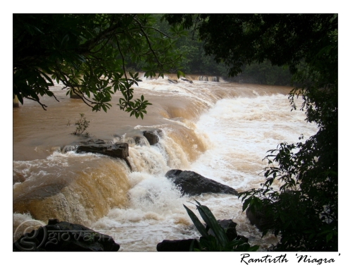
Ramtirth Waterfall

Ramtirth, is not much of a waterfall… but I like to call it the ‘Niagra’ of Ajara..;)

Ramtirth - Ajara

True to the definition of ‘water’ plant!

Ramtirth downstream

The river flows on bringing life and prosperity to the vast township around.

Birds at Ramtirth

A very amusing set of crows, who braved the rain on this weather-worn tree.

The return trip had its own share of exciting sights! Take this rock for instance…

Boulder - Anmod

I wonder how long it will take for it to shift a little 😉

Rock flowers - Anmod

This was another sight that called for a closer inspection. The entire rock was strewn with flowers. Here today, gone tomorrow.

The weekend was over… the memories remain.

Watangi way

Will I make another visit to this place? Anytime!

Fields and Flowers

Once an idea gets into your head, it remains there… and pushes you to do something about it.

This time it was the idea to get out somewhere on the weekend… anywhere… But when a variety of factors coalesce together on the work-family-home front, from domestic chores to incomplete assignments, there were only a couple of hours before the mind begins to panic at the dawn of another Monday!

So with the breeze in our face (and a bit of drizzle), and the wind in our hair, we decided to explore the territory closest to home—around Porvorim! The plan was to detour off the Mandovi bridge, ride along the river and make our way to the other side of the Chorao island.

Wasteland-Succoro

These marshy regions are home to a number of migratory birds once the rains have past. (Note to self: Have to visit these places around Oct-Nov again). Some chose to call it ‘wastelands’ (being non-agricultural), I choose to call it ‘home’

Flowers in the fields

Every part of the fields were filled with flowers!

Flowers-Pods

From a distance they look unattractive, but move in closer and you will find beauty beyond compare!

Backwaters

The place is a labyrinth of interconnected waterways.

Clouds-Hills

Any place that you stop offers a serene and calm view.

senenity-calm water

The mind was refreshed. It was time to head back.